

Staff Research Highlight - Water sources and threshold behaviors of streamflow generation in a mountain headwater catchment
We’re pleased to highlight this publication, co-authored by Aquanty’s senior scientist, Hyoun-Tae Hwang, which examines the water sources and threshold behaviours of streamflow generation in a mountain headwater catchment.
Staff Research Highlight - Development of a fully integrated hydrological fate and transport model for plant protection products: incorporating groundwater, tile drainage, and runoff
This research investigates how the integrated hydrological modelling of plant protection products (PPPs) such as pesticides can provide a more comprehensive understanding of their environmental behavior across groundwater, surface water, and tile drainage systems.

HGS HIGHLIGHT – Estimating cumulative wastewater treatment plant discharge influences on acesulfame and Escherichia coli in a highly impacted watershed with a fully-integrated modelling approach
In this research highlight, researchers used HydroGeoSphere (HGS) to explore the impact of wastewater treatment plant (WWTP) discharge on surface water contamination in a mixed-use watershed in Ontario, Canada. The study focused on tracking acesulfame, a commonly used artificial sweetener, and Escherichia coli (E. coli), a fecal indicator, to understand how these contaminants move between surface and groundwater systems. Understanding the interactions between surface water and groundwater is critical in watersheds where WWTP discharge contributes to regional water quality concerns.
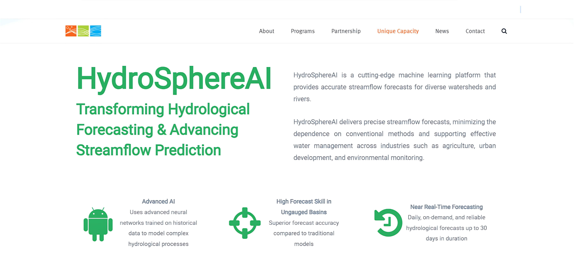
HydroSphereAI featured in OWC’s Innovation Showcase
We’re proud to share that Aquanty’s cutting-edge hydrological forecasting tool HydroSphereAI is now featured in the Ontario Water Consortium (OWC) Innovation Showcase. The OWC highlights our machine-learning based streamflow forecasting tool, designed to address the complex water management challenges of today and position Aquanty as a leader in hydrological forecasting solutions.

“Homegrown Technologies Could Play a Key Role in the World’s Water Future” - Aquanty Featured in CWRA’s Water News Magazine
We’re proud to share that Aquanty has been highlighted in a recent issue of the CWRA’s Water News Magazine. This article explores the innovative tools we’ve developed to tackle 21st-century water resource challenges, positioning Aquanty as a leader in hydrologic system modelling both in Canada and internationally.

HGS RESEARCH HIGHLIGHT – Assessing the impact of surface water and groundwater interactions for regional-scale simulations of water table elevation
In this research highlight, researchers Hugo Delottier, Oliver S. Schilling, and René Therrien, conducted an in-depth exploration of how the interaction between surface water (SW) and groundwater (GW) affects the accuracy of regional-scale simulations of water table elevations in Southern Quebec. This investigation was conducted over a vast 36,900 km² regional aquifer system, which is marked by a complex hydrogeological setup. The area of study includes a regional bedrock aquifer that is overlain by discontinuous Quaternary sediments, presenting a challenging environment for accurate hydrological modelling.
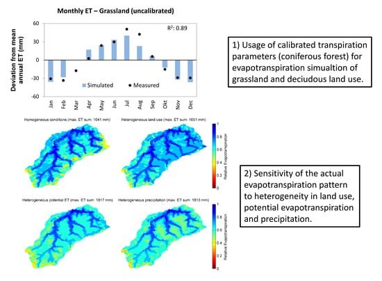
HGS RESEARCH HIGHLIGHT – Using High-Resolution Data to Test Parameter Sensitivity of the Distributed Hydrological Model HydroGeoSphere
By integrating HydroGeoSphere in this study, the researchers demonstrate its versatility in accommodating high-resolution data and conducting sensitivity analyses across different spatial scales. Precipitation emerges as the most sensitive input data, significantly influencing total runoff and peak flow rates. Additionally, the study highlights the importance of spatially distributed land use parameterization in accurately simulating evapotranspiration components and patterns.
HGS RESEARCH HIGHLIGHT – Groundwaters in Northeastern Pennsylvania near intense hydraulic fracturing activities exhibit few organic chemical impacts
In this comprehensive study, researchers investigated the potential impact of hydraulic fracturing activities on groundwater quality in Northeastern Pennsylvania, using a HydroGeoSphere model of a region with thirty gas-well pads. Modelling results suggest a low probability of systematic groundwater organic contamination in the region.

HGS RESEARCH HIGHLIGHT – How Does Topography Control Topography-Driven Groundwater Flow?
In a study led by Xiaolang Zhang, Jiu Jimmy Jiao, Wensi Guo, researchers have comprehensively explored the mechanisms governing topography-driven groundwater flow. Their research showcases the complexities between varying rainfall patterns, topographic features, and groundwater flow dynamics, offering invaluable insights into hydrological processes.

HGS RESEARCH HIGHLIGHT – Comparing alternative conceptual models for tile drains and soil heterogeneity for the simulation of tile drainage in agricultural catchments
This research highlight explores tile drainage systems within agricultural catchments, with the goal of refining hydrological modeling methodologies. The study explores the impact of soil heterogeneity on model simulations, revealing its significance at smaller scales. Overall, offering valuable insights into improving the representation of tile drainage in hydrological models, crucial for sustainable water management in agricultural landscapes.