

Manitoba Forage and Grasslands Association wins Water Canada innovation award
We’re proud to share that the Manitoba Forage and Grassland Association (MFGA) has been awarded the 2025 Early Adopter/Innovation Partnership Award from Water Canada for its pioneering work with Aquanty on hydrologic modelling in Manitoba.
The award recognizes outstanding collaborations that advance Manitoba and Canada’s water sector through innovation and partnership. MFGA earned this recognition for its leadership in applying Aquanty’s HydroGeoSphere-based modelling platform to better understand and manage water resources across agricultural landscapes.

Manitoba Cooperator - Farm climate adaptation on tap with MFGA project
The Manitoba Co-operator has featured the latest MFGA initiative, with comments from Dr. Steve Frey, Aquanty’s Director of Research Services, highlighting how advanced modelling is supporting more climate-resilient farming in Manitoba. The new project “Evaluating climate change impacts on Manitoba’s forage and grassland landscapes” will build on the MFGA Aquanty hydrologic model to simulate how changing climate conditions could impact water availability, land use, and agricultural sustainability across the Pembina Valley and Assiniboine West Watershed Districts.

HGS RESEARCH HIGHLIGHT – Modeling fate and transport of E. coli in a small watershed with grazing lands around a pond
This research investigates the fate and transport of E. coli in a small watershed with grazing lands surrounding a pond, using HydroGeoSphere (HGS) to develop a mechanistic numerical model. Understanding how E. coli moves through surface and subsurface water systems is crucial for managing microbial contamination risks in agricultural watersheds, where livestock activities can significantly impact water quality.

HGS RESEARCH HIGHLIGHT – Monetizing the role of water in sustaining watershed ecosystem services using a fully integrated subsurface–surface water model
This research, co-authored by David R. Lapen, Susan Preston, Tariq Aziz, and Steven K. Frey, highlights the role of subsurface water in sustaining ecosystem services during droughts. Using HydroGeoSphere (HGS), the team analyzed the South Nation Watershed (SNW) in eastern Ontario, emphasizing how subsurface water supports evapotranspiration in agricultural landscapes.

Staff Research Highlight - Development of a fully integrated hydrological fate and transport model for plant protection products: incorporating groundwater, tile drainage, and runoff
This research investigates how the integrated hydrological modelling of plant protection products (PPPs) such as pesticides can provide a more comprehensive understanding of their environmental behavior across groundwater, surface water, and tile drainage systems.

HGS RESEARCH HIGHLIGHT – Same soil, different climate: Crop model intercomparison on translocated lysimeters
In this research highlight, researchers explored the dynamics of crop modelling across diverse climatic conditions using translocated lysimeters. The study investigates how crop models perform when applied to the same soil under different climatic regimes, shedding light on the complex interplay between soil and crop dynamics amidst changing environmental conditions.

HGS RESEARCH HIGHLIGHT – Comparing alternative conceptual models for tile drains and soil heterogeneity for the simulation of tile drainage in agricultural catchments
This research highlight explores tile drainage systems within agricultural catchments, with the goal of refining hydrological modeling methodologies. The study explores the impact of soil heterogeneity on model simulations, revealing its significance at smaller scales. Overall, offering valuable insights into improving the representation of tile drainage in hydrological models, crucial for sustainable water management in agricultural landscapes.
Ontario Water Consortium - WIG Project Highlight: Using machine learning to make flood forecasts less wishy-washy
The Ontario Water Consortium has written an excellent article which reviews Aquanty’s latest technology driven initiative that can be used to manage water resources. With support from the Ontario Water Consortium’s Water Industry Growth Program, Aquanty is making machine-learning (i.e. artificial intelligence) driven real-time flood forecasting a reality.

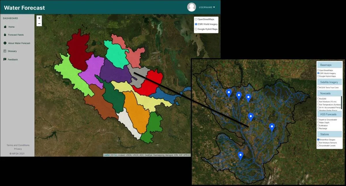
Manitoba Cooperator - Field-level water forecasts: There’s an app for that
The Manitoba Cooperator has written an excellent article (with comments from Dr. Steve Frey, Aquanty’s Director of Research Services) which reviews some of the new technology driven initiatives to manage water resources throughout Manitoba, with a specific focus on the newly developed MFGA Aquanty Forecasting Tool - a real-time hydrologic forecasting system for decision-support around water movement, soil health, climate risk assessment & mitigation in the Assiniboine River Basin and Pembina River watersheds.