
Manitoba Forage and Grasslands Association wins Water Canada innovation award
We’re proud to share that the Manitoba Forage and Grassland Association (MFGA) has been awarded the 2025 Early Adopter/Innovation Partnership Award from Water Canada for its pioneering work with Aquanty on hydrologic modelling in Manitoba.
The award recognizes outstanding collaborations that advance Manitoba and Canada’s water sector through innovation and partnership. MFGA earned this recognition for its leadership in applying Aquanty’s HydroGeoSphere-based modelling platform to better understand and manage water resources across agricultural landscapes.

HydroClimateSight Feature Highlight: Real-Time Soil Moisture Forecasting on Demand
At Aquanty, we're redefining how soil moisture forecasting is done in precision agriculture. Our latest innovation brings together real-time weather data, advanced hydrologic modelling, and cloud automation to deliver accurate, hyper-local soil moisture forecasts, on demand, at the click of a button. Built for farmers, consultants, researchers, and planners, this tool provides the insights needed to optimize irrigation, support crop health, and plan field operations with confidence.

HydroClimateSight Feature Highlight: Unlock Powerful Insights with HydroClimateSight’s Remote Sensing Map Layers
Modern water and land resource management relies on timely, reliable, and spatially detailed data. Aquanty’s HydroClimateSight platform empowers decision-makers by integrating a diverse set of authoritative datasets into a range of physics-based and machine-learning based hydrologic models. HydroClimateSight provides direct access to many of these datasets through the Remote Sending tab to help users better understand the datasets that go into these models. Let’s review some of the available data layers that give HCS users visual and analytical insights sourced from globally recognized organizations, government agencies, and open-data initiatives.

HydroClimateSight Feature Highlight: Understanding Ensemble vs Deterministic Forecasting in HydroSphereAI
We’re excited to announce that short-range streamflow forecasting is now available in HydroSphereAI! Our new short-range forecasts offer detailed predictions for the day ahead with hourly output intervals. To address the lack of uncertainty information typical of deterministic systems, we’ve introduced a lagged ensemble approach, giving you a clearer picture of forecast confidence in the near term.

Manitoba Cooperator - Farm climate adaptation on tap with MFGA project
The Manitoba Co-operator has featured the latest MFGA initiative, with comments from Dr. Steve Frey, Aquanty’s Director of Research Services, highlighting how advanced modelling is supporting more climate-resilient farming in Manitoba. The new project “Evaluating climate change impacts on Manitoba’s forage and grassland landscapes” will build on the MFGA Aquanty hydrologic model to simulate how changing climate conditions could impact water availability, land use, and agricultural sustainability across the Pembina Valley and Assiniboine West Watershed Districts.

HGS RESEARCH HIGHLIGHT – Groundwater recharge from overbank floods
This study, published by researchers using a fully coupled surface-subsurface flow model, explores the process of overbank flood recharge, which is important for estimating aquifer sustainable yield.

Ontario Water Consortium - WIG Project Highlight: Using machine learning to make flood forecasts less wishy-washy
The Ontario Water Consortium has written an excellent article which reviews Aquanty’s latest technology driven initiative that can be used to manage water resources. With support from the Ontario Water Consortium’s Water Industry Growth Program, Aquanty is making machine-learning (i.e. artificial intelligence) driven real-time flood forecasting a reality.

HGS RESEARCH HIGHLIGHT – The coastal aquifer recovery subject to storm surge: Effects of connected heterogeneity, physical barrier and surge frequency
This research analyzes the combined effects of connected heterogeneity, physical barriers, and surge frequency on coastal aquifer recovery. Using HydroGeoSphere (HGS), Aquanty’s sophisticated modeling platform known for its ability to simulate coupled surface water-groundwater interactions, the team investigated a series of modeling cases in heterogeneous and equivalent homogeneous aquifers.

Manitoba Cooperator - Field-level water forecasts: There’s an app for that
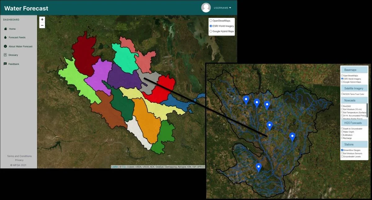
The Manitoba Cooperator has written an excellent article (with comments from Dr. Steve Frey, Aquanty’s Director of Research Services) which reviews some of the new technology driven initiatives to manage water resources throughout Manitoba, with a specific focus on the newly developed MFGA Aquanty Forecasting Tool - a real-time hydrologic forecasting system for decision-support around water movement, soil health, climate risk assessment & mitigation in the Assiniboine River Basin and Pembina River watersheds.

Manitoba Co-operator - Hydrology forecasting tool drills down to field level
Farmers in the Assiniboine River basin will soon have access to a new tool designed to help them make predictions about water flow at the field level. The tool was developed by the hydrologic modelling firm Aquanty, in cooperation with the Manitoba Forage and Grasslands Association. They are able to combine their model with remote sensing data on things like soil moisture levels and real time groundwater monitoring sensors to set the initial conditions before launching a hydrologic forecast. “Combining that with insights on how water management infrastructure is maintained during floods and droughts and using cloud computing infrastructure, we can readily construct these models and deliver them via an app to your fingertips,”
