

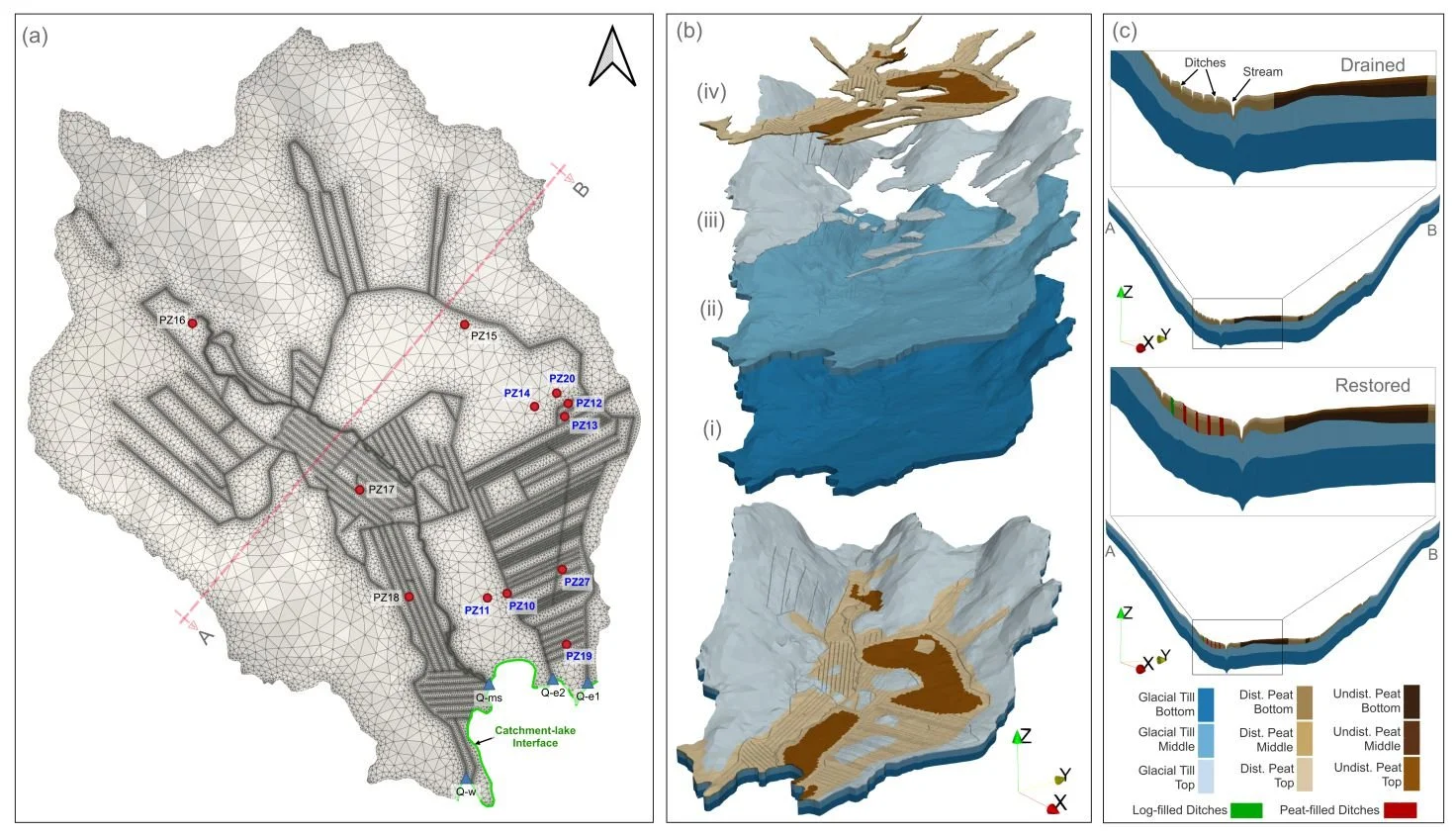
HGS RESEARCH HIGHLIGHT – How Does Rewetting Propagate Through Restored Peatlands? An Integrated Surface–subsurface Modelling Analysis of Water–table Dynamics
We’re pleased to highlight this publication, which investigates how peatland restoration alters groundwater table dynamics across drained boreal peatlands using fully integrated hydrologic modelling. This study leverages HydroGeoSphere (HGS) to simulate coupled surface–subsurface flow processes and evaluate spatial patterns of groundwater response following ditch blocking and rewetting interventions, addressing long-standing challenges in predicting restoration outcomes across heterogeneous peatland landscapes.
HGS RESEARCH HIGHLIGHT – Three‐Dimensional Geostatistical Inverse Analyses of Transient Head and Temperature Data From a Long‐Term Heat Tracer Test
We’re pleased to highlight this staff research highlighted which investigates how three-dimensional geostatistical inverse modelling can improve characterization of subsurface heterogeneity in groundwater systems. This study leverages HydroGeoSphere (HGS) to simulate fully coupled groundwater flow and transport processes within a stochastic inversion framework, addressing long-standing challenges in estimating spatially distributed hydraulic conductivity fields from limited observational data.
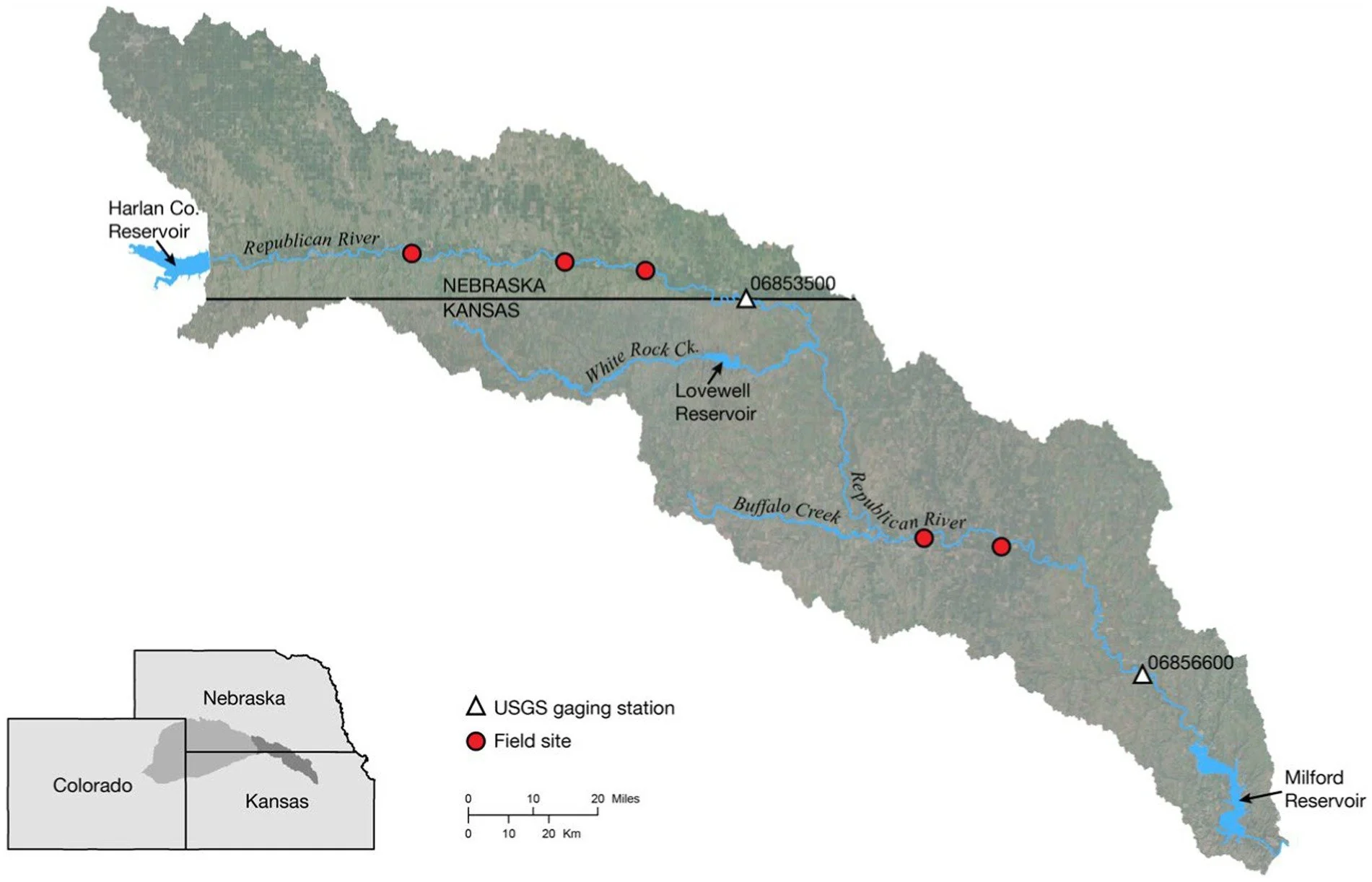
HGS RESEARCH HIGHLIGHT – Quantifying the effects of water management decisions on streambank stability
This publication co-authored by Q. Wei, A. Brookfield, and A. Layzell, investigates how water management decisions influence streambank stability by altering subsurface hydrologic conditions. This study leverages HydroGeoSphere (HGS), coupled with the surface water operations model OASIS, to address long-standing challenges in linking reservoir operations, groundwater pumping, and hydrologic dynamics to the physical mechanisms driving streambank failure.
HGS RESEARCH HIGHLIGHT – Stable Water Isotopes Improve Calibration and Flow path Identification in Integrated Hydrological Model
This publication co-authored by Omar Ashraf Nimr, Hannu Marttila, Anna Autio, and Pertti Ala-Aho, investigates how stable water isotopes can improve calibration, uncertainty reduction, and flow path identification in fully integrated surface–subsurface hydrological models. This study leverages HydroGeoSphere (HGS) to explicitly simulate both hydrologic processes and isotope transport, addressing long-standing challenges related to equifinality and internal process realism in groundwater–surface water modelling.
HGS RESEARCH HIGHLIGHT – A hydraulic mixing-cell method to quantify the groundwater component of streamflow within spatially distributed fully integrated surface water–groundwater flow models
This research highlight co-authored by D. Partington, P. Brunner, C.T. Simmons, René Therrien, A.D. Werner, G.C. Dandy, and H.R. Maier, introduces a hydraulic mixing-cell (HMC) method to accurately quantify the groundwater component of streamflow within fully integrated surface–subsurface hydrologic models. This study leverages HydroGeoSphere (HGS) to address long-standing challenges in decomposing streamflow generation mechanisms without relying on tracer transport simulations or simplifying assumptions about groundwater discharge.
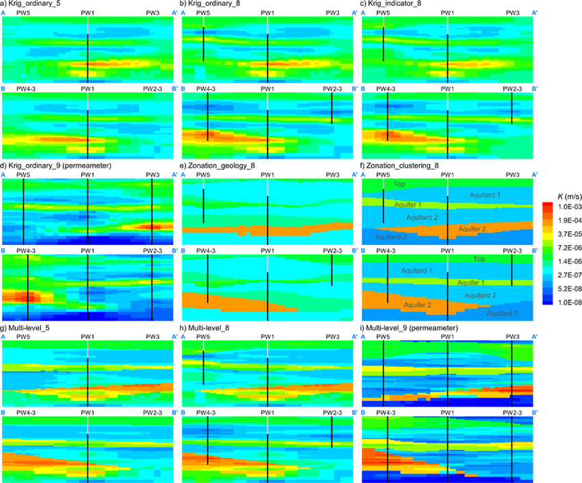
HGS RESEARCH HIGHLIGHT – Characterizing Spatial Heterogeneity of Hydraulic Conductivity Using Borehole NMR in a Complex Groundwater Flow System
This research highlight co-authored by Chenxi Wang, Colby M. Steelman, and Walter A. Illman, investigates how borehole nuclear magnetic resonance (NMR) logging can be used to characterize subsurface heterogeneity and improve the representation of hydraulic conductivity in groundwater flow models. This study leverages HydroGeoSphere (HGS) to evaluate the predictive performance of NMR-derived hydraulic conductivity (K) models and assess how different spatial interpolation and upscaling approaches influence flow and drawdown predictions in a highly heterogeneous aquifer system.
HGS RESEARCH HIGHLIGHT - Groundwater flow and age in topography-driven groundwater flow systems with geological barriers
The research examines how groundwater age and flow systems are influenced by topography and geological barriers, using numerical simulations to clarify the interaction between surface-driven flow and subsurface heterogeneity. Traditional models of topography-driven flow often assume homogeneous geologic conditions, which can obscure the role of stratigraphic variations in shaping groundwater movement and age distribution. This study offers a detailed exploration of how structural barriers— such as low-permeability formations— interrupt or redirect groundwater pathways and affect the spatial and temporal distribution of groundwater age.

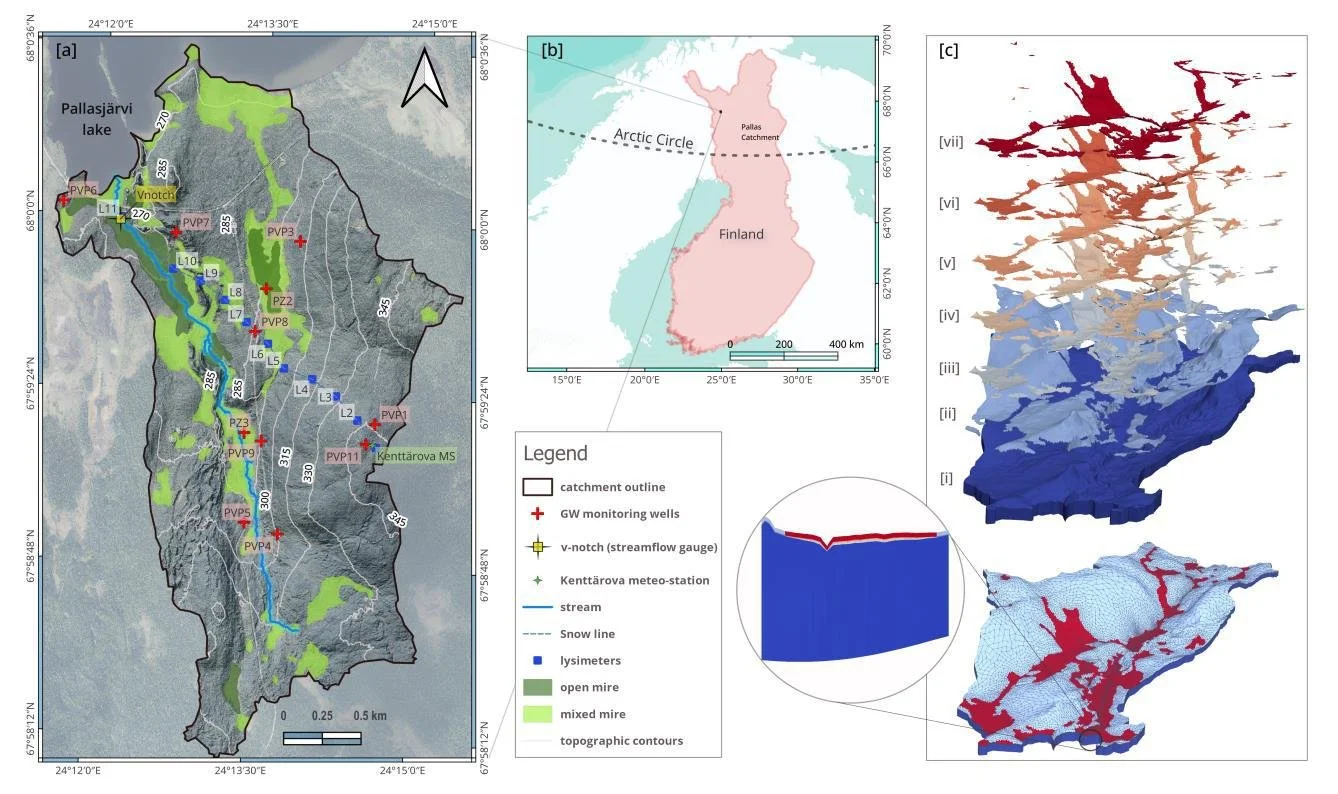
HGS RESEARCH HIGHLIGHT – External and internal drivers behind the formation, vegetation succession, and carbon balance of a subarctic fen margin
In this research publication, researchers investigated the formation, vegetation succession, and carbon balance of peatland margins in Finnish Lapland. This study leverages HydroGeoSphere (HGS) alongside paleoecological records and remote sensing to address long-standing challenges in understanding how new peatland areas initiate, expand, and influence climate through carbon cycling.

Staff Research Highlight - Improving precision in regional scale numerical simulations of groundwater flow into underground openings
The study presents a novel numerical framework to improve the accuracy of regional-scale groundwater flow simulations into underground openings, such as tunnels and deep geological repositories. Traditionally, simulating groundwater inflows into engineered underground structures has involved significant simplifications, often treating tunnels as drain features or imposing boundary conditions that fail to fully capture the physical behavior of fluid flow around these voids. This research addresses those limitations by introducing a new numerical boundary condition to simulate groundwater flow into underground openings more accurately.

HGS RESEARCH HIGHLIGHT - Is the Water Balance of Your Waste Rock Pile Reliable? A framework for Improving Assessment of Water Inputs and Outputs for a Typical Storage Facility
This research focuses on understanding the dynamics of topography-driven groundwater flow systems using fully-coupled surface–subsurface hydrologic modelling. This study addresses long-standing challenges in representing nested flow systems by simulating interactions between climate, topography, and groundwater without relying on potentially unrealistic, static boundary conditions.