

HGS RESEARCH HIGHLIGHT – The effects of land subsidence and its mitigating measures on shallow groundwater salinization in the low-lying coastal plain of East Japan
The research investigates how land subsidence and mitigation measures, specifically pumping stations and ditch systems in Shirako Town, Japan's lower Nabaki River region, interact. Land subsidence, caused by natural and human factors, heightens flood risks in coastal areas, challenging infrastructure stability and environmental sustainability. While pumping stations and ditches aim to manage surface water levels and reduce floods, their impact on groundwater salinity near tidal rivers is unclear. Using a coupled surface-subsurface model, the study reveals potential risks like saline water intrusion into groundwater.

HGS RESEARCH HIGHLIGHT – Analyzing variation of the water table level with three-dimensional numerical simulations to assess reclamation techniques for an acidic tailings impoundment
As an extension of the last HGS research highlight titled ‘Improving control of contamination from waste rock piles’, this next research highlight within this series looks at a study conducted by the same researchers and explores the effects of thin cover deposition on managing water table levels in acidic tailings impoundments, while utilizing HydroGeoSphere (HGS) for in-depth simulations.

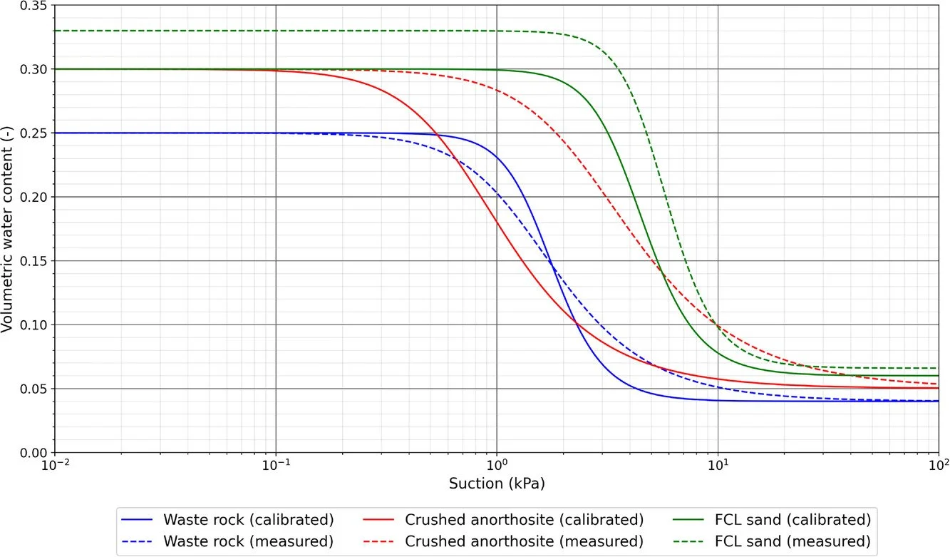
HGS RESEARCH HIGHLIGHT – Improving control of contamination from waste rock piles
This study conducted by researchers investigates how well compacted cover layers on waste rock piles can mitigate infiltration into these waste piles, reducing the overall potential for oxidation of sulfidic waste materials and control environmental contamination. The research provides a detailed examination of how different cover configurations and hydrogeological conditions affect the performance of these covers in mitigating risks associated with waste rock piles.

HGS RESEARCH HIGHLIGHT – Assessing the impact of surface water and groundwater interactions for regional-scale simulations of water table elevation
In this research highlight, researchers Hugo Delottier, Oliver S. Schilling, and René Therrien, conducted an in-depth exploration of how the interaction between surface water (SW) and groundwater (GW) affects the accuracy of regional-scale simulations of water table elevations in Southern Quebec. This investigation was conducted over a vast 36,900 km² regional aquifer system, which is marked by a complex hydrogeological setup. The area of study includes a regional bedrock aquifer that is overlain by discontinuous Quaternary sediments, presenting a challenging environment for accurate hydrological modelling.
HGS RESEARCH HIGHLIGHT – A black-box automated approach to calibrate numerical simulations and optimize cover design: Application to a flow control layer constructed on an experimental waste rock pile
In this study, researchers developed and tested a novel black-box automated approach to calibrate numerical simulations and optimize cover designs for waste rock piles at mining sites. This work was undertaken by a team of scientists focusing on improving waste rock pile stability and minimizing environmental contamination.

HGS RESEARCH HIGHLIGHT – Rapid transport from the surface to wells in fractured rock: A unique infiltration tracer experiment
In this study, researchers investigated the dynamics of rapid transport from the surface to monitoring wells in fractured rock environments using a unique infiltration tracer experiment. The focus was on understanding how tracers or contaminants move quickly through fractures to wells, which is crucial for assessing water quality and contamination risks.

HGS RESEARCH HIGHLIGHT – Groundwater recharge from overbank floods
This study, published by researchers using a fully coupled surface-subsurface flow model, explores the process of overbank flood recharge, which is important for estimating aquifer sustainable yield.

Staff Research Highlight - Evaluating the significance of wetland representation in isotope-enabled distributed hydrologic modeling in mesoscale Precambrian shield watersheds
Aquanty’s very own Arghavan Tafvizi had her PhD research paper “Evaluating the Significance of Wetland Representation in Isotope-Enabled Distributed Hydrologic Modeling in Mesoscale Precambrian Shield Watershed” published in the Journal of Hydrology.

HGS RESEARCH HIGHLIGHT – Impact of Baseflow on Fish Community in the Ungcheon Stream, Korea
In this research highlight, researchers have explored how baseflow influences fish habitats in the Ungcheon stream, located downstream of the Boryeong Dam in Korea.

HGS RESEARCH HIGHLIGHT – HGS-PDAF (version 1.0): a modular data assimilation framework for an integrated surface and subsurface hydrological model
In their recent publication, Qi Tang and her team present an advancement in hydrological modelling: HGS-PDAF (version 1.0). This modular data assimilation framework is tailored specifically for integrated surface and subsurface hydrological modelling, offering a powerful tool for understanding and managing water resources in a changing environment.