
HGS RESEARCH HIGHLIGHT - Mega-Tidal and Surface Flooding Controls on Coastal Groundwater and Saltwater Intrusion Within Agricultural Dikelands
The study highlighted here makes full use of the density dependent flow modelling capabilities of HydroGeoSphere to investigate the impacts of climate change on groundwater-ocean interactions, and how sea-level rise, tides and storm-surges impact the long-term position of an upper saline plume in a coastal agricultural dikeland in Nova Scotia, Canada.

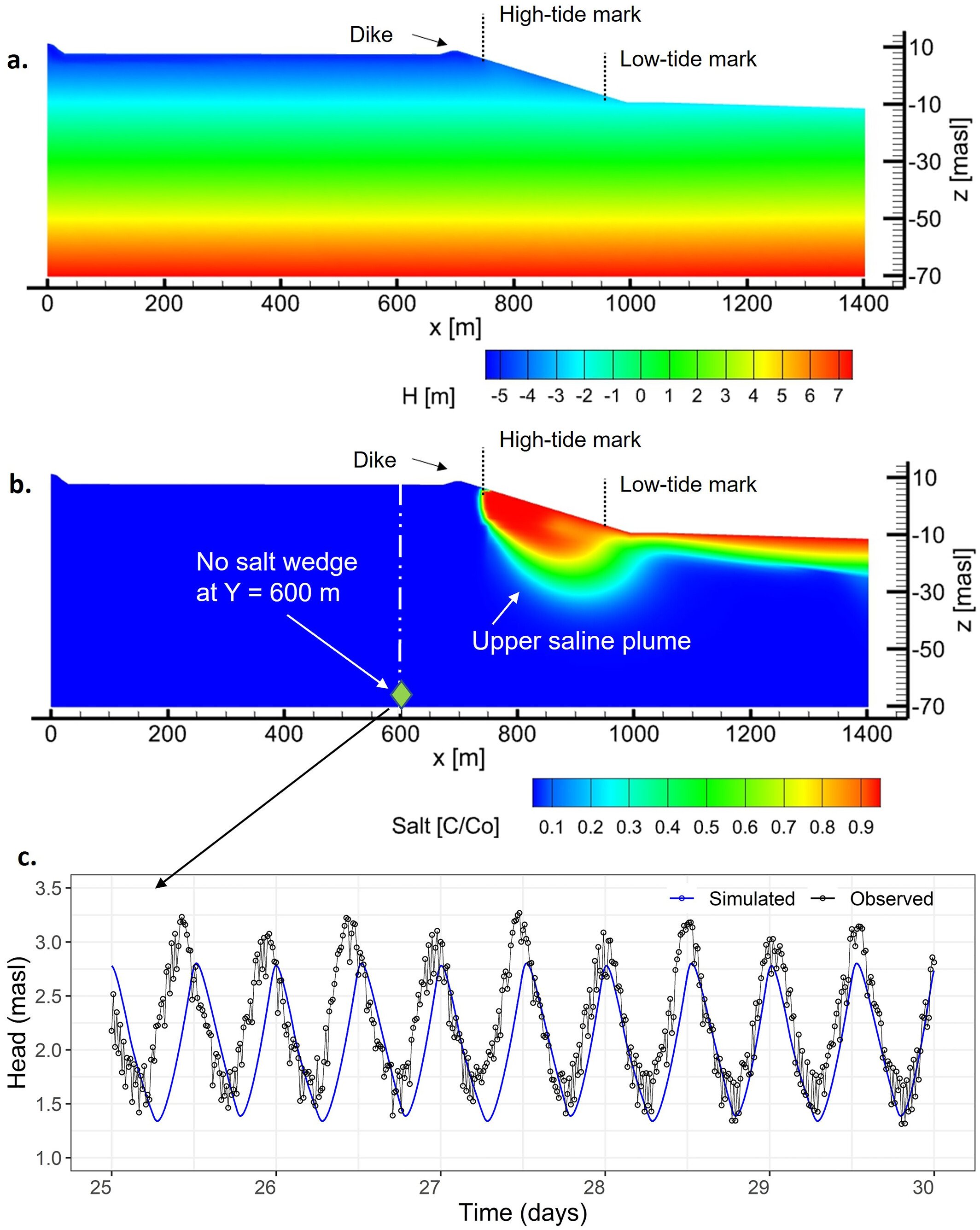
HydroGeoSphere Research Highlight - "Lateral and vertical saltwater intrusion into a coastal aquifer"
Climate change is projected to substantially increase the global mean sea level, which will adversely impact coastal communities worldwide.

HGS RESEARCH HIGHLIGHT – Managing climate change impacts on the Western Mountain Aquifer: Implications for Mediterranean karst groundwater resources
A new study investigates the impact of climate change on water availability within a 9000 sqkm karstic aquifer in Israel and the West Bank, and couples HydroGeoSphere to a soil-epikarst water balance model.

HGS RESEARCH HIGHLIGHT – Landscape restoration after oil sands mining: conceptual design and hydrological modelling for fen reconstruction
This study by researchers at the University of Waterloo investigates whether fen peatlands could be reconstructed on post-mine sites. Oil sand extraction can be very harmful to the natural land surface and can have lasting impacts on local ecosystems. This paper focuses on the fen peatlands that cover 65% of the landscape in Fort McMurray, Alberta. Our ability to reinstate these peatlands after mining operations has not truly been tested at large scales, and there are many uncertain factors that can impact reclamation plans for these sensitive wetlands.
HGS RESEARCH HIGHLIGHT – Potential influence of climate change on ecosystems within the Boreal Plains of Alberta
This paper by researchers at the University of Alberta discusses the possible impacts of climate change in the Boreal Plains in Northern Alberta, Canada. The sensitive ecosystems in this area have developed under a delicate water balance, while climate change and warming temperatures threaten to shift water availability. This study looks at ponds, peatlands with sparse black spruce, and hillslopes with predominantly aspen forests as the features of focus.

"Climate Change Impact Analysis using HydroGeoSphere" - Aquanty Webinar
As the relevant components of the global climate (e.g. temperature and precipitation patterns/intensity) drift further from historically reliable patterns, it becomes harder and harder to rely on these historical patterns as part of hydrologic studies. This is why HydroGeoSphere is an incredibly powerful tool for long-term climate change impact analyses of hydrologic systems.
HGS RESEARCH HIGHLIGHT – Impacts of Climate Change and Different Crop Rotation Scenarios on Groundwater Nitrate Concentrations in a Sandy Aquifer
This study by researchers at the University of Guelph investigated the impacts of various crop rotation scenarios and climate change on groundwater nitrate concentrations in a 155 sq-km agricultural sub-watershed in Norfolk County, Ontario.
HGS RESEARCH HIGHLIGHT – Evaluating Climate Change Impacts on Soil Moisture and Groundwater Resources Within a Lake-Affected Region
This study investigates how climate change could impact groundwater and soil moisture within the Great Lakes Basin (GLB). Groundwater is a resource that is relied on for agriculture, industry, municipalities, and drinking water. Approximately one-quarter of the 33 million inhabitants of the GLB depend on groundwater as their primary freshwater source. Given its extreme value as a natural resource, the impacts of climate change on groundwater need to be well understood, and fully-integrated models that incorporate such large water bodies (let alone an entire basin-scale system) are rare.
HGS RESEARCH HIGHLIGHT – Towards a climate-driven simulation of coupled surface-subsurface hydrology at the continental scale: a Canadian example
This study is an excellent example of how a physics-based approach to simulating integrated hydrology with HydroGeoSphere allows researchers to overcome the limitations of data scarcity. Allowing water to flow naturally (or as ‘naturally’ as possible for a digital environment) also simplifies the calibration process, as a well conceptualized watershed scale model should be able to accurately represent the integrated hydrology of the watershed inherently.