HGS Research Highlight - Schilling et al., 2014
This post features a study recently completed by Schilling et al., 2014 that used HGS in conjunction with ecological data to provide quantitative guidance towards sustainable management within the semi-arid Tarim River Basin in Western China. For more information on this study please contact the corresponding author: Oliver Schilling (oliver.schilling@unine.ch)
Using tree ring data as a proxy for transpiration to reduce predictive uncertainty of a model simulating groundwater–surface water–vegetation interactions
Authors: O.S. Schilling, J. Doherty, W. Kinzelbach, H. Wang, P.N. Yang, and P. Brunner
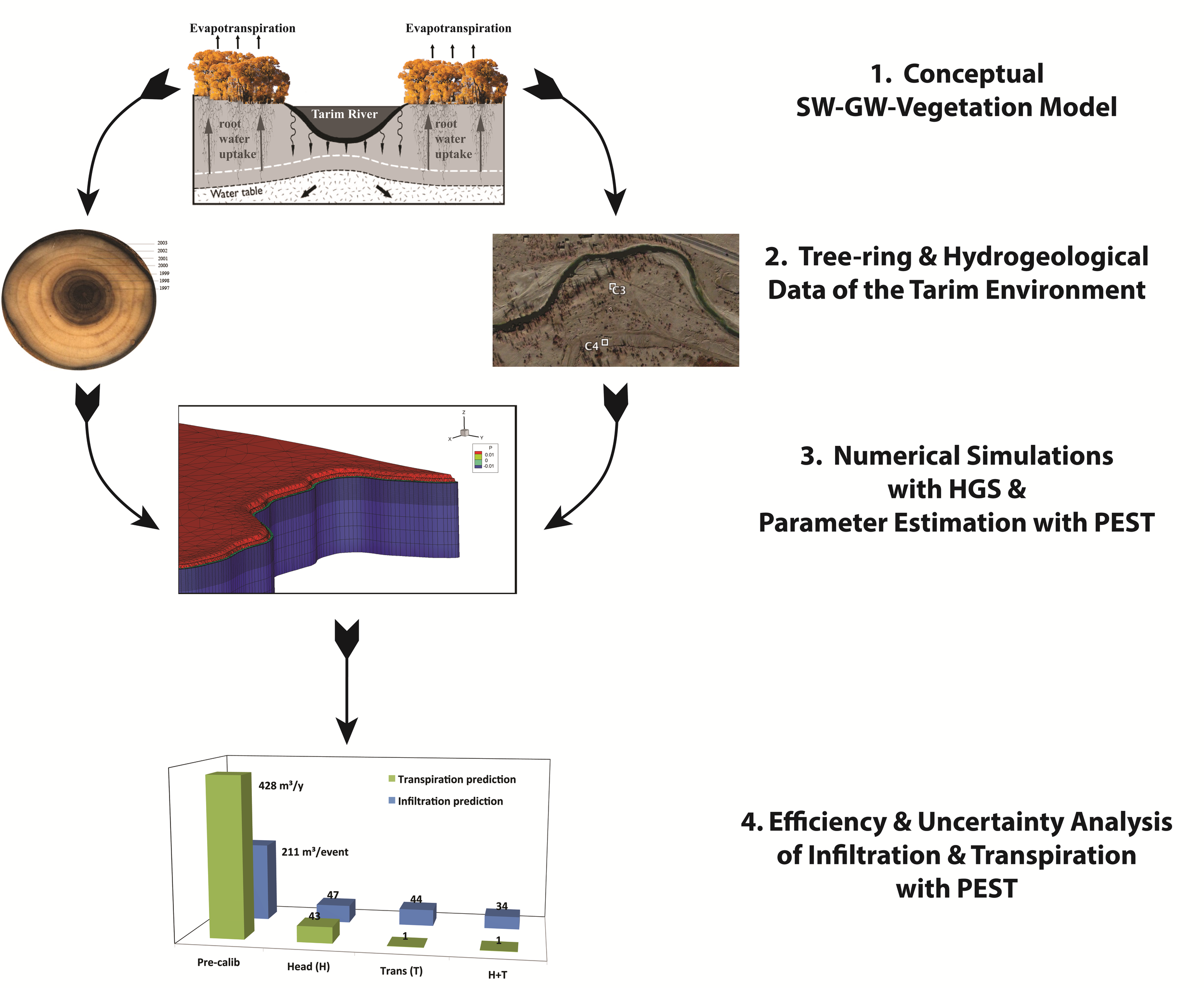
Flow Chart of Modelling Process (Images courtesy of the Authors. Satellite Imagery from Google Earth (Digital Globe, 2015)).
The overarching goal of this study is to provide a quantitative basis for managing water resources in the semi-arid Tarim Basin in Western China. The increased use of surface water in the upstream of the Tarim River has led to the drying up of a stretch of over 300km, with devastating consequences for the riparian Populus Euphratica forests. To save these valuable ecosystems, the Chinese government initiated the “Ecological Water Conveyance Project”. The goal of this initiative is to stop the decline of the downstream ecosystems by periodically reducing the amount of water diverted for irrigation in the upstream. In order to provide quantitative guidance towards sustainable management, this project integrated ecological data with advanced mathematical modelling of surface water, groundwater and vegetation, using HydroGeoSphere (HGS). The ecological data consists of tree-ring records that encapsulate historic information on the hydraulic and ecological history along the Tarim River: The tree-ring growth was used as a proxy of transpiration by the Populus Euphratica trees, the predominant vegetation along the Tarim River. In terms of computational cost, such models are extremely demanding. To overcome this limitation, new state-of-the-art calibration approaches for parameter estimation and uncertainty analysis were employed using PEST. The HGS based simulations of the riparian eco-system showed that the information encapsulated in tree-rings is extremely valuable in the context of modeling ecosystems dynamics and their feedback with hydrological systems: tree-ring growth used as a proxy for historic transpiration rates allow to significantly reduce (1) uncertainty of parameters linked to vegetation and infiltration processes, and (2) improve the reliability of predictions of transpiration and infiltration events substantially. Specific to the project area, the study allowed quantifying the efficiency of the ecological water releases. Furthermore, a basis for highly targeted field campaigns that will help to simulate and optimize the allocation of water for ecosystems and agricultural use could be provided.
The HGS Research Highlight Series features recent publications and projects completed using HGS. If you have recently completed a project using HGS and would like to see it featured here please contact sberg@aquanty.com.