HGS RESEARCH HIGHLIGHT – Simulating fully-integrated hydrological dynamics in complex Alpine headwaters: potential and challenges
Thornton, J. M., Therrien, R., Mariéthoz, G., Linde, N., & Brunner, P. (2022). Simulating fully‐integrated hydrological dynamics in complex Alpine headwaters: potential and challenges. In Water Resources Research. American Geophysical Union (AGU). https://doi.org/10.1029/2020wr029390
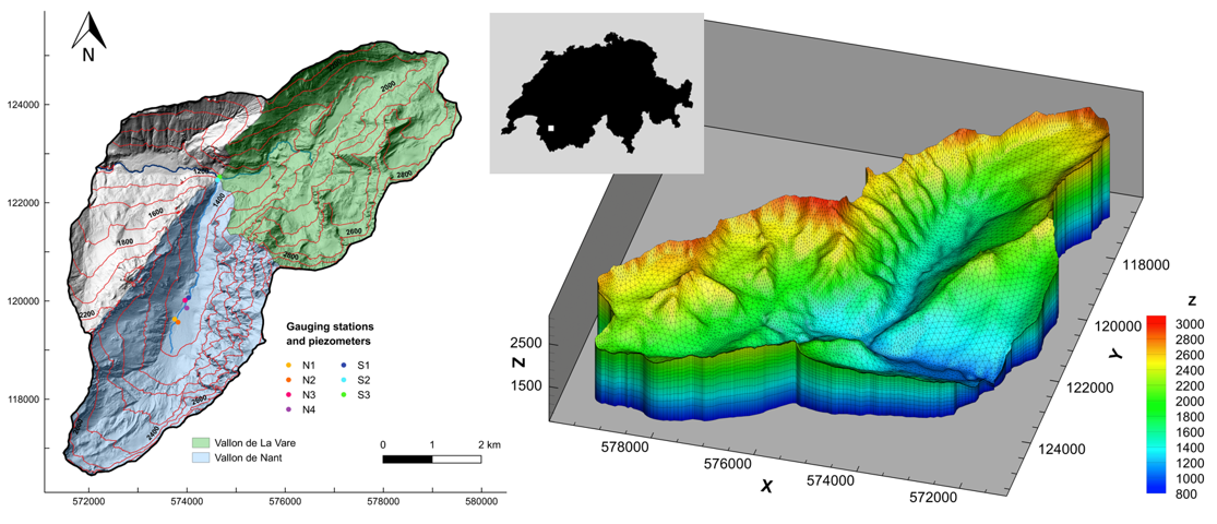
Figure 1: The study site with two adjacent headwater catchments in the western Swiss Alps (the Vallon de Nant and the Vallon de La Vare) and associated model mesh (23 layers, ~272,000 nodes).
Our latest HydroGeoSphere research highlight presents the first known attempt to automatically calibrate a catchment-scale integrated hydrologic model in a mountainous region. Alpine areas are inherently difficult to model, with large elevation gradients (steep, rugged terrain), complex geology and highly variable weather conditions, but nevertheless a satisfactory model calibration was achieved. The model incorporated fully integrated surface/groundwater flow, evapotranspiration processes, and dynamic snowmelt (using an energy balance-based representation of snow processes), all underpinned by a detailed 3D geological model. Using PEST-HP, the model was calibrated using a large number of model parameters, including those related to evapotranspiration properties, surface flow (e.g. friction coefficient) and subsurface flow (e.g. conductivity, porosity) properties, against observed streamflows and groundwater levels.
The calibrated model was also used to test the impact that common simplifications/assumptions have on model performance. In each scenario, a new version of the model was constructed and compared to the results of the calibrated ‘full complexity’ model (i.e. the reference model). By testing various scenarios against the reference model the authors were able to isolate the influence of key simplifications/assumptions on model performance. Four scenarios were tested, including:
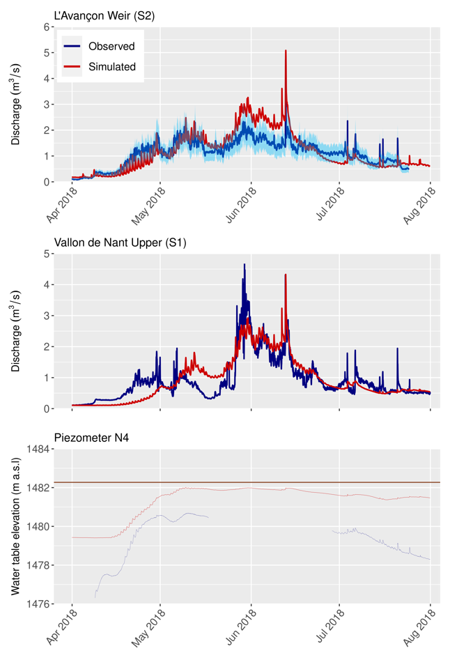
Figure 2: Streamflow and groundwater levels for the fully-calibrated “full complexity” model using hourly, 25 m resolution forcing data.
An “impermeable subsurface, no ET” scenario in which the porous medium was deactivated (i.e. no infiltration or subsurface flow processes).
A “limited vertical extent” scenario in which the porous medium/subsurface was limited to 30m in depth, and all elements below 30m from the ground surface were deactivated.
A “spatially uniform forcing” scenario in which spatially averaged meteorological forcing data were applied to the whole model.
A “near-surface geology from global maps” scenario in which subsurface parameters were applied based on a very coarse global scale hydrogeological map (i.e. GLHYHMPS 2.0).
These simplified scenarios provided several insights into the modeling results. The model was much “flashier” under the limited vertical extent scenario, highlighting the necessity for a sufficiently deep model domain. The spatially uniform forcing scenario led to lower simulated spring streamflow peaks, especially at higher elevations. Finally, employing the near-surface geology from global maps scenario did not provide satisfactory results, highlighting the importance of carefully defined subsurface conceptual models derived from local data to generate locally meaningful outputs.
Abstract:
Highly simplified approaches continue to underpin hydrological climate change impact assessments across the Earth’s mountainous regions. Fully-integrated surface-subsurface models may hold far greater potential to represent the distinctive regimes of steep, geologically-complex head water catchments. However, their utility has not yet been tested across a wide range of mountainous settings. Here, an integrated model of two adjacent calcareous Alpine headwaters that accounts for 2D surface flow, 3D variably-saturated groundwater flow, and evapotranspiration is presented. An energy balance-based representation of snow dynamics contributed to the model’s high-resolution forcing data, and a sophisticated 3D geological model helped to define and parameterize the subsurface structure. In the first known attempt to calibrate a catchment-scale integrated model of a mountainous region automatically, numerous uncertain model parameters were estimated. The salient features of the hydrological regime could ultimately be satisfactorily reproduced–over an 11-month evaluation period, the Nash-Sutcliffe efficiency of simulated streamflow at the main gauging station was 0.76. Spatio-temporal visualization of the forcing data and simulated responses further confirmed the model’s broad coherence. Presumably due to unresolved local subsurface heterogeneity, closely replicating the somewhat contrasting groundwater level signals observed near to one another proved more elusive. Finally, we assessed the impacts of various common model simplifications and assumptions on key simulated outputs, finding strongly affected model performance in many cases. Although certain outstanding challenges must be overcome if the global uptake of integrated models in mountain regions is to increase, our work demonstrates the feasibility and benefits of their application in such complex systems.


